Undersea geospatial capabilities offer asymmetric advantages in the field
Enter KeywordWe live in an era where undersea/maritime infrastructure assets are being probed or threatened in strategically sensitive waters.
- In the Indonesia–China context, undersea monitoring devices and seabed sensors raise questions aboutwho is surveilling whom, in whose EEZ, with what legal and strategic implications.
- In the Strait of Hormuz context, attacks or interference with undersea cables create both economicdisruption and escalation risk in a chokepoint vital for global trade and naval operations.
These situations need an integrated view
- Seafloor topography, cable and sensor layouts, shipping lanes, and territorial boundaries.Real-time vessel tracks, anomalous behaviours, and environmental conditions.Subsurface risk (tampering, mines, physical damage) and second-order impacts (communications loss,escalation pathways).
That is exactly the sort of multi-layer, spatially explicit problem SynTerra IQ is designed to handle
The ADF’s geography is no longer just the Australiancoastline; it extends deep into the Indo-Pacific toprotect sea lanes and undersea infrastructure
Richard Marles, Minister for Defence
SynTerra IQ Capture Layer for Military Use
1. Surface, coastal and littoral capture Defence customers could use SynTerra IQ’s capture layer to unify multi-sensor maritime intelligence:
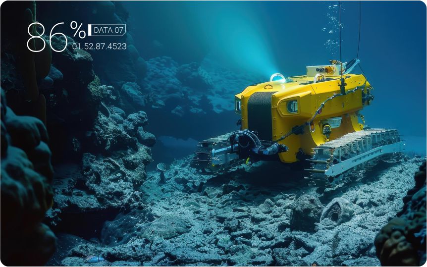
- Deploy GNSS-enabled survey vessels, USVs, and aircraft/UAVs with EO/IR, SAR, and LiDAR to map coastlines, ports, approaches to chokepoints, and cable landing sites, then ingest that directly into SynTerra IQ as structured, validated spatial data.
- Use 360-degree mobile mapping for critical coastal infrastructure (naval bases, landing stations, coastal radar and SIGINT sites), so commanders have asset-level detail when planning protection or rapid repair.
This creates a high-fidelity “ground (and coast) truth” baseline for normal operations against which anomalies can be detected.
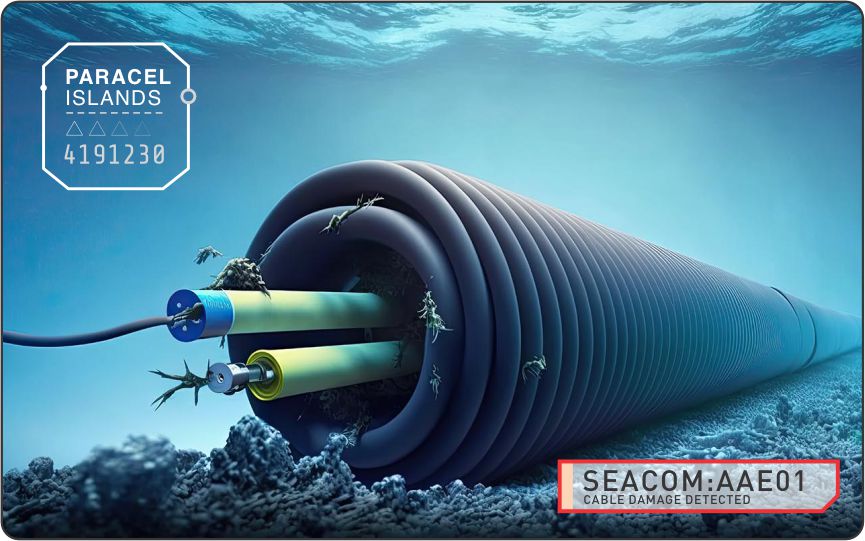
2. Subsurface and undersea capture (ERT, geophysics, cables) SynTerra IQ’s subsurface and littoral capabilities map neatly onto undersea cable and seabed-sensor scenarios:
- Use Electrical Resistivity Tomography (ERT), multibeam sonar, side-scan sonar, and magnetometers along cable routes and around suspected foreign devices to characterise the sub-seafloor environment and detect anomalies (disturbed sediments, buried objects, changes around existing infrastructure).
- Conduct repeated geophysical passes to track changes over time (e.g., a new object near a cable, a shift in resistivity profile suggesting tampering, or new emplaced monitoring hardware).
- Integrate environmental sampling (e.g., turbidity plumes from recent seabed disturbance) and oceanographic surveys into the same geospatial model for context.
For a commander worried about covert undersea monitoring or sabotage, this yields a time-stamped, confidence-scored picture of “what is on and in the seabed, and what is changing”.
Virtualisation Layer: Maritime and Undersea Digital Twin
3. Maritime-theatre digital twin: Using precedents from maritime digital twins and maritime surveillance twins, SynTerra IQ’s virtualisation layer could provide:
- A live, synthetic Earth maritime twin of a theatre (e.g., South China Sea approaches, Sunda Strait, or Strait of Hormuz) combining bathymetry, cable routes, EEZ/territorial boundaries, AIS and non-cooperative tracks, seabed sensors, and coastal surveillance assets.
- Persistent rendering of both surface and subsurface objects, so a JOC can visualise the relationship between shipping patterns, undersea cables, seabed devices, mines, and patrol routes in one 3D environment.
- XR-ready environments for mission rehearsal (e.g., boarding operations near a suspected tampering vessel, mine-clearance ops around cables, or rapid-repair drills following cable damage).
This is directly aligned with how other maritime and defence digital-twin programmes are being used to “test before they invest” and explore what-if scenarios collaboratively.
4. Scenario simulation and rules of engagement: Within that twin, defence planners can:
- Simulate adversary behaviour: positioning of undersea sensors, cable-cutting patterns, or grey-zone activities just inside or outside maritime boundaries, and assess detection probabilities.
- Run wargamed responses: increased patrols, new sensor placements, alternative routing of traffic or data, or coordinated diplomatic and information operations, while tracking risk to escalation or miscalculation.
SynTerra IQ’s ability to unify multi-source geospatial data into a persistent twin enables iterative CoA development that’s traceable and shareable across agencies and coalition partners.
Intelligence Layer: GeoAI, Large Geospatial Model and Semantic Reasoning
5. Large Geospatial Model for maritime and undersea domains A defence-specific LGM on SynTerra IQ could be trained on:
- Historical AIS, radar and EO/SAR imagery over specific sea lanes and chokepoints to learn “normal” patterns for commercial, fishing, and military vessels.
- Historical incidents of cable damage, undersea sensor deployments, mine warfare, and clandestine seabed activity, labelled by outcome (accident vs deliberate, state vs non-state) to support risk estimation.
- Environmental and oceanographic data (currents, depth, seabed type) that affect both sensor performance and likely adversary tactics.
The LGM can then flag anomalies in behaviour, routes, or undersea conditions, and prioritise them for human review.
6. Agentic GeoAI for maritime ISR and response: Agentic GeoAI running on SynTerra IQ could orchestrate defence workflows such as:
- Continuous anomaly detection: agents watch for vessels loitering near cables, AIS dark ships following suspicious tracks, or new objects detected on the seabed; they then generate alerts with geospatial context and confidence scores.
- Tasking and collection: when an anomaly is detected, agents recommend additional sensor tasking (UAV flyover, sonar pass, ROV inspection) and update the twin as new data arrives.
- Impact assessment: GeoAI agents estimate the operational impact if a given cable is cut (e.g., bandwidth loss, redundancy paths), the legal/strategic implications of intervention at that location, and suggest mitigations.
Because SynTerra IQ already emphasises orchestration of deterministic workflows with probabilistic agents, this is a natural extension for C6ISR-style defence missions.
7. Semantic, confidence-scored Q&A for commanders The semantic layer and knowledge graph give commanders and planners a “plain language” interface over the entire geospatial picture:
- A JOC director could ask: “Which undersea cables in our EEZ have seen anomalous vessel activity in the last 72 hours, and what is your confidence?” and receive a ranked list with map overlays and reasoning trace.
- Legal and policy teams could ask: “Show me possible hostile acts against seabed infrastructure in the last month that occurred inside disputed boundaries,” and examine evidence linked to authoritative datasets and treaties.
The key is that each answer carries an overall and per-component confidence score, plus provenance, aligning with military demands for explainable, auditable intelligence.

Sovereign Geospatial PaaS for Defence
SynTerra IQ’s managed PaaS model translates well to defence requirements:
Sovereign hosting and control: running in an Australian or partner-nation sovereign cloud (or air-gapped infrastructure) to meet defence security and data-sovereignty requirements.
Hardened, zero-trust architecture: adopting serverless, secured microservices, and strong identity management for multi-classification, multi-agency deployments (e.g., separate but correlated views for navy, signals, intelligence, and foreign partners).
Integration with existing C2/C6ISR systems: ingesting and publishing standard defence geospatial formats so SynTerra IQ becomes the “spatial intelligence spine” rather than a silo.
Defence Value This mirrors how other maritime and defence digital-twin and geospatial platforms are being rolled out as shared environments across agencies, e, intelligence, and partner organisations while maintaining appropriate security boundaries and data control.
Why SynTerra IQ is a good fit for undersea operations:
From a defence buyer’s perspective, SynTerra IQ brings several differentiators that map cleanly to maritime and undersea crises:
- Vertical integration: from field/subsea capture through synthetic theatre twins to semantic GeoAI, reducing seams where information is lost or delayed.
- Sovereign control: alignment with national sovereign-AI and data-sovereignty goals, critical in sensitive military theatres.
- Confidence and explainability: explicit confidence scoring, provenance, and reasoning traces, all essential for accountable military decision-making.
- Multi-domain extensibility: while the examples here focus on undersea and maritime, the same stack extends to air, land, cyber-physical infrastructure, and space situational awareness.